I use a variety of models in my work at UKCEH and in collaborative projects. Here is a brief 'menu':
|
|
I have been using the land surface model JULES since ~2010 when I was a postdoc at Univ. Oxford (see Marthews et al. 2012). I can run JULES in a number of configurations:
JULES is also the only model for which I currently maintain an online tutorial (JULES From Scratch) describing how to port it to and run it on your local server. |
|
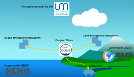
In the CHAMFER project (started 2022), I will be using the coupled model UM_JULES, which means not using JULES on its own, but run in lock-step with climate and ocean models (see Marthews et al. 2023).
Intended resolution: 500 m covering the whole UK + surrounding parts of Eire, The Netherlands, Norway and France. |
|
|
I implemented CaMa-Flood on JASMIN in 2020 during the Hydro-JULES project. In Marthews et al. (2022), I reported on using runoff produced by JULES (in the eartH2Observe project) to drive CaMa-Flood (at global 0.25deg resolution) and make predictions about tropical wetlands.
Since 2021, I have also been working with Dr Douglas Clark to produce a branch of the JULES model that contains a lot of the functionality of CaMa-Flood. This is currently called JULES-Camaflood and we hope to be able to put this into the trunk of JULES in early 2024. |
|
|
Starting mid-2023, I have been working on a port of the Community Earth System Model (CESM) (which includes the Community Land Model CLM) to a compute machine in the UK.
|
Please note that some of these runs are historical/were used in previous projects and, in many cases, I used versions of the models concerned that (were current at the time but) are now behind the curve. In these cases, I most likely do NOT have up-to-date versions of these configurations.
For the JULES model in particular, there is a configurations page that I do keep up to date as part of my work maintaining the JULES website.
I used to use several older models as well, by the way, including SWEAT (see Marthews et al. 2008). I have created my own models too, e.g. FORLIGHT (see Marthews et al. 2008), GA2 (see Marthews et al. 2015) and a model for predicting deforestation extents in Cambodia (see Evans et al. 2013).