The information below was collected together by Toby at the request of Nigel Fisher and others in 2014 as part of the revision of the Wytham Woods website (currently still in progress).

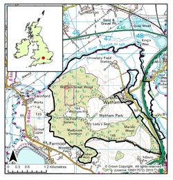
Wytham Woods is shown left, with the John Krebs Field Station visible to the NE (see here for a zoomable streetmap).
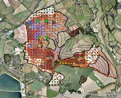
Wytham is host to many ongoing research experiments, including the Smithsonian Forest Dynamics Plot in Wytham Great Wood (18 ha rectangle shown in purple, just north of the Chalet) and the Earthwatch Core Plot (1 ha plot within the Smithsonian plot shown in red).
General references:
The Wytham Woods Book (2011)
The Wytham Woods Atlas (1981).
Trends in vegetation cover and species richness in Wytham Woods 1974-1999 (2000).

GIS Maps for general use
For anyone with an interest in Wytham, we provide here some GIS resources:
(1) A General map of Wytham showing rides and boundaries, including data provided by Wytham ECN, Earthwatch, the University of Oxford Department of Zoology and the University of Oxford Ecosystem Lab. Double-click on Wytham/GeneralWythamMap.mxd to open. This map is in shapefile format (when opening these map layers, you will need to change the links to the data sources to correspond with your own filing system, e.g. see here for ArcGIS).
(2) A Map of Wytham using publicly-available data. Double-click on ArcGIS10/Maps/Wytham.mxd to open. This map is in geodatabase format and includes most of the data contained in (1).
Further GIS resources are available at many web locations:
- Here is a map of SSSIs in and around Wytham (n.b. this is a visualisation only: for the most up-to-date layers of SSSIs and other Environment Agency data, please see here).
- Academic users and nonprofit workers can access MasterMap and other services (e.g. geological data from BGS) via the EDINA digimap service. If you wish to view OS raster products (e.g. street map), these can be added to your GIS map from EDINA digimap as well (see here for how to do this in ArcGIS and QGIS).
Historical maps accessible through the Bodleian Library in Oxford
Finally, there are some historical maps of Wytham and the surrounding area:
[Collection of maps relating to Wytham Wood 195?]
[Wytham Woods and field station 1955-1987]
n.b. These maps are not available in electronic format.
Finally, there are some historical maps of Wytham and the surrounding area:
[Collection of maps relating to Wytham Wood 195?]
[Wytham Woods and field station 1955-1987]
n.b. These maps are not available in electronic format.
Information on map projections for Wytham
If you're using a handheld GPS device then the default setting is usually WGS1984. In the UK (except Northern Ireland), ramblers generally change the setting on their GPS to OSGB36 (the National Grid datum) which is more accurate for the GB mainland (e.g. see here).
For GB mapping in GIS packages, as long as your data is collected / stored using one of the following two coordinate systems you will be fine (UK-specific spatial data typically follows the British National Grid, but more generalised global data will usually follow WGS84):
(1) GB specific -> OSGB36 = EPSG:27700 = ESRI:British National Grid. The Ordnance Survey (British) National Grid (BNG) is based on the OSGB36 datum (Ordnance Survey Great Britain 1936, based on the Airy 1830 ellipsoid), and was introduced after the retriangulation of 1936–1962.
(2) WORLD (anywhere / neutral) -> WGS84 = EPSG:4326 (or ETRS89, which is a refinement of WGS84 used for European locations)
For more information, please see the Ordnance Survey - Guide to coordinate systems in Great Britain, which provides an introduction to mapping coordinate systems and the use of GPS datasets with Ordnance Survey mapping.
The Ordnance Survey Coordinate Transformation Tools: The OS provides tools for converting between (1) and (2) above (and also UTM eastings and northings). Use either the Single coordinate transformation tool or the Batch coordinate transformation tool (these use the OSTN02 transformation). These coordinate conversions or these may also be useful.
Finally, about latitudes and longitudes: please note that these transformation tools generally convert between BNG and ETRS89 latitudes/longitudes not OSGB36 lat/longs (n.b. if you float the pointer over a location in ArcGIS in the maps above, remember that it will display the coordinates bottom right in OSGB36 lat/longs not ETRS89 lat/longs: don't get confused!).